
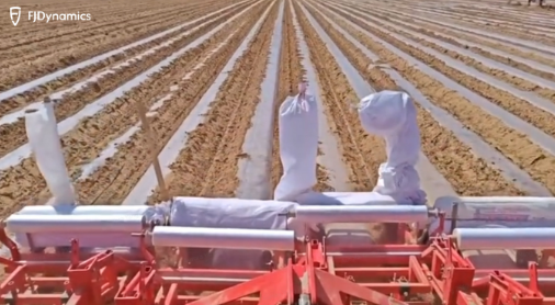
In today’s farming, new ideas help growers get the most out of their crops while cutting down on hard work. One game-changing method is film mulching—a simple but powerful technique where farmers cover soil with thin plastic sheets. This “blanket” traps warmth and moisture, stops weeds from growing, and shields plants from pests, promoting healthier vegetables and bigger harvests.
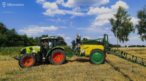
Automating a 10-Year-Old UNIA Sprayer for Smart Spraying Control: FJD ISOBUS Upgrade Success in Poland
Today, farming is all about being smart and efficient. Farmers need their machines to work exactly right, save materials, and finish jobs faster. But what about older machines? Can they use modern advanced technology? FJDynamics recently proved that they absolutely can!
Dual Antennas & Dual Controls: FJD Land Leveling System Proves Its Success in South Africa
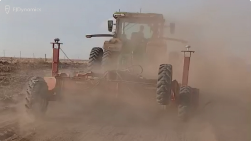
Leveling a field or preparing soil for farming requires the ground to be perfectly flat or shaped just right. This is where graders come in – big machines with a long blade that scrape and move earth. For years, this work has relied on skill and traditional tools. But now, new technology is making it much more precise and efficient.

LiDAR Mapping of the Yeongdong-daero Underground Complex: A Field Case with FJD Trion Scanner
LiDAR Mapping of the Yeongdong-daero Underground Complex: A Field Case with FJD Trion Scanner In the heart of Seoul’s ever-evolving Gangnam district, a massive underground transformation is underway. Spanning 1.2 kilometers beneath one of the city’s busiest urban corridors—from Bongeunsa Station (COEX Intersection) to Samsung Station—the Yeongdong-daero Underground Space Complex is a next-generation urban infrastructure initiative that combines mobility, sustainability, and spatial innovation. When it’s finished in 2028, the project will include a 21,000-square-meter underground transportation hub with integrated railroads and roadways, all buried up to 60 meters below the ground. On top of it all will be a large public park, creating a striking mix of a green space and the engineering marvel happening beneath. Building this massive project requires incredible precision and a lot of data. To make sure every stage of the construction is perfect, a local surveying team used advanced 3D scanning technology from FJDynamics. The FJD smart scanners were used to track and record every detail of the work, creating a precise digital record. This helps the team keep an eye on the project’s progress and ensures everything is built exactly as planned over the many years of the project. Capturing Complex Data with FJD Trion S2 & P1 To document this huge underground project, the construction team utilized two LiDAR handheld scanners from FJDynamics: the Trion S2 and the Trion P1 . These scanners use SLAM to create detailed maps in real time without needing a GPS signal. This is a crucial feature, especially when working in deep tunnels and enclosed spaces where GPS doesn’t work.Each scanner has a specific purpose. The Trion S2 can scan objects up to 120 meters away and is very precise, with an accuracy of about 1.2cm. This makes it perfect for mapping the larger, more open parts of the construction site. The Trion P1 is lighter and easier to carry. It scans up to 70 meters away with an accuracy of about 2cm, making it the ideal tool for tight spaces and detailed indoor areas.The handheld design of both scanners makes them easy to use in small hallways, on stairwells, and in shafts. But for hard-to-reach places like high ceilings or deep pits, the team attached the scanners to the FJD extension pole. This allowed them to safely and accurately scan areas they couldn’t reach on their own. With the simple accessory, the scanners were much more versatile and kept the workers safe while getting all the data they needed.In addition, both scanners have a built-in panoramic camera. This camera does two important things: it lets the operator see what they’re scanning in real time on their device, and it adds color to the 3D maps. After colorization, the data becomes much easier to understand and visualize. This makes it simpler for everyone on the team to collaborate and double-check the quality of the work, even when they’re not on the job site. Streamlined Post-Processing with Trion Model Software After all the scanning was done, the team used Trion Model , a cloud point processing software from FJDynamics. The software helped them turn the raw scan data into useful 3D information for easier project management and reporting. Here are some of the features that impressed them the most: With easy-to-use interfaces, these features all work together to make sure the team can quickly and accurately analyze the data, making such a huge construction project easier to manage. Real-World Impact: Faster and Safer Underground Construction By using the FJD Trion S2 and P1 handheld scanners together with the Trion Model software, the surveying team created a smooth field-to-office 3D scanning solution for the complex Yeongdong-daero project. This integrated approach allowed them to capture accurate and detailed 3D data in real time and then easily process it afterward. This powerful combination of hardware and software gave the team several key advantages. They could monitor the construction progress every month, from the ground level down into the deepest underground sections. They were also able to quickly spot any differences between the actual build and the original design plans. Finding these issues early helps prevent expensive mistakes and delays later in the project.Beyond just monitoring, this solution also helped the team with safety and communication. It created detailed digital records that were easy to share for inspections and audits, and made the job safer by reducing the need for workers to take manual measurements in dangerous or hard-to-reach areas. The colorized 3D visualizations made it much easier for everyone involved—from contractors to engineers and clients—to understand the project’s progress and stay on the same page. A Smarter Way to Document Complex Construction The Yeongdong-daero Underground Complex is a great example of how mobile 3D scanning technology is becoming essential for modern construction, especially in tough underground environments. By using handheld scanners like the Trion S2 and P1 with the Trion Model software, the construction teams can work smarter and safer. This combination of tools allows them to have a clear, digital view of the entire project, which makes it easier to manage, improves safety for workers, and keeps everyone informed at every step of the project.If you’re interested in smart surveying tools or want to learn more about how FJD Trion technology works, please feel free to reach out to our dealers and distributors in your area, or just contact us directly here. We’ll be happy to help and get back to you as soon as we can: Contact FDynamics in User Case # FJD Geospatial Solution FJD Trion™ P1 LiDAR Scanner FJD Trion S2 Series Scanners Geospatial
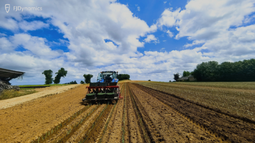
Precise Garlic Planting: How FJD Autosteering Tech is Revolutionizing Farms in France
France is famous for many things: fine art, long history, and of course, good food. And a key part of that delicious food is a small but powerful ingredient: garlic. From busy Paris markets to quiet farm kitchens, garlic is a must-hav
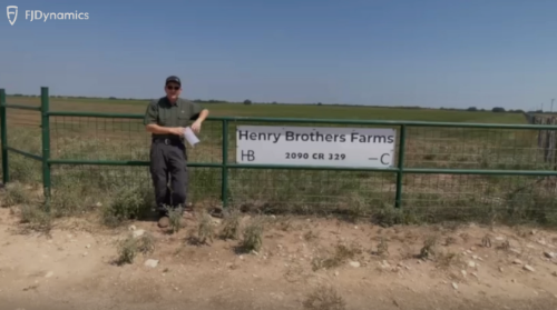
Smart Farming Glory in Texas: The Story of Henry Brothers Farms with FJD Autosteering
In the heart of Uvalde County, Texas, lies Henry Brothers Farms, an American farm where history runs as deep as the roots of their crops. This farm has been in the Henry family since 1901, growing from humble beginnings into a large and
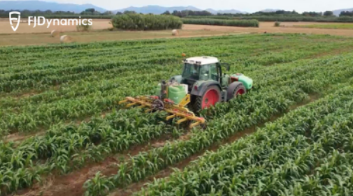
Sorghum Farming in Spain: FJD ISOBUS TC-SC Empowers TeeJet Sprayer for Precise Crop Protection
In today’s fast-paced world of agriculture, farmers need their machines to work perfectly, save money on resources, and finish tasks quickly. But what about older machines, the ones farmers have used for many year
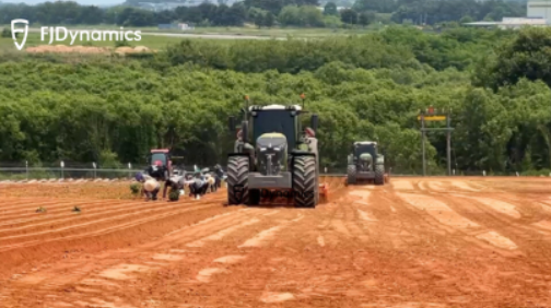
Human-Machine Farming: FJD Autosteer Tech Empowers Sweet Potato Cultivation in Iksan, South Korea
Farming has always been a mix of tradition and hard work. For many years, the work was guided by the physical effort of farmers and their machines. But today, a big change is happening in fields all over the world, thanks to new technology. This is especially true in places like Iksan, South Korea, a city famous for a simple crop: the sweet potato. By using smart farming tools, Iksan is not only growing a great product but also building a stronger ec
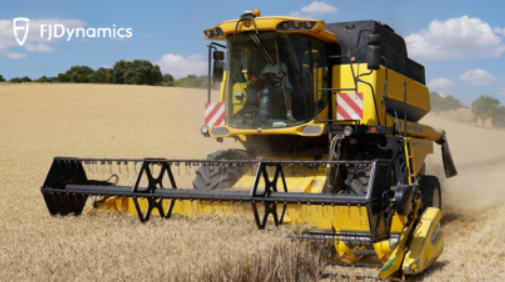
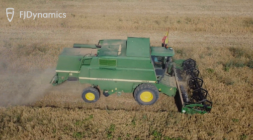
375 Hectares, 400 Hours, 1 FJD AT2 Max Kit: Conquering Wheat Harvest on Hilly Fields in Spain
In the sun-baked plains of Castilla-La Mancha, Spain, where rolling hills meet a wide-open sky, farming is more than a job—it’s a family legacy. For a third-generation farmer, the land tells a story of tradition, hard work, and adapting to new ways. But in recent years, th
Tractor Autosteering: FJD Smart Farming Tech Empowers Wheat Harvesting in Toledo, Spain
Located in the heart of Spain, Castilla-La Mancha is an autonomous region with a long history of farming. While many people think of its famous vineyards that make great wine or the fields of purple flowers that give us saffron, another crop is even more important: wheat. It is the most essential crop and the backbone of the region’s economy. Castilla-La Mancha is one of Spain’s top areas for this crop, along with grapes, olives, and garlic. In fa